|
|
|
Early Soviet The Time Bomb Planted By Andrew Andersen and Georg Egge
|
|
|
|
The
Treaty of Kars, 13.10.1921 The partition of the South Caucasus as a
result of a series of wars in 1920-1921 was finalized by the Treaty of Moscow
signed on March 16, 1921 by the representatives of Soviet Russia and Kemalist
Turkey. The provisions of the Treaty confirmed the new borders of Armenia
that had just left the Soviet orbit as a result of an anticommunist uprising
(see above) and Georgia whose independence was recently recognized de jure by
the Allied powers and whose army and militias were still desperately fighting
in an attempt to repel the Soviet invasion. During the intensive talks
preceding the signing ceremony, the territories of the two nations were
partitioned and borders re-drawn in the absence of the representatives of
that nations. The Soviet leadership did not even invite to Moscow any representatives
of the puppet Soviet Revkoms of
Armenia and Georgia. Almost seven months later, on October 13,
1921, the treaty containing basically the same provisions as the Treaty of
Moscow was signed in Kars. This time it was signed not only by the representatives
of Turkey and Russia but also by the ones representing the Soviet governments
of Armenia, Azerbaijan and Georgia. According to the Treaty of Kars, the
treaties of Sevres and Alexandropol
(see above) were denounced and both the Turkish and Armenian sides
agreed to forgive each other all the “military crimes and mistakes” committed
by their representatives during all the wars, conflicts and ethnic cleansings
of 1915-1920. However, despite the formal renouncement of
the technically illegal Treaty of Alexandropol, the Treaty of Kars
reconfirmed the Turkish-Armenian boundary outlined in it by leaving Turkey
with most of the territories conquered during the Turkish-Armenian war as
well as the Soviet-Turkish war against Georgia[1].
Turkey re-gained almost all the territories lost to the Russian Empire during
Russo-Turkish war of 1978, except the northern half of Achara (i.e. northern
half of the territory of Batum) and the tiny Shuragel (Aghbaba) sector in the
north-eastern corner of the territory of Kars. Within the above territories
ceded to Turkey were the towns of Artvin, Ardahan, Oqam, Olor, Olty, Poskhov,
Sarykamysh, Kaghyznman and Kars. Turkey was also granted the county of
Surmala of the former Erevan province to the south of the river of Aras with
the town of Ighdyr and the mountain of Ararat (the national symbol of
Armenia). The county of Surmala had never been a part of Turkey before,
except a short period between 1724 and 1735, and as per the Treaty of Kars,
Turkey became the only country among those defeated
during World War I that ended up with a territorial gain (see Map 12).
Turkey also dropped all the claims to the counties of Sharur-Daralaghes and
Nakhichevan of the former province of Erevan under the condition that the
county of Nakhichevan, western part of the county of Sharur-Daralaghez (more
or less correspondent with Bash-Norashen sector) and a small strip in the
county of Erevan with the village of Sadarak, was to become a special
autonomous territory under the protection of Soviet Azerbaijan. The creation
of a special autonomy in Sharur-Nakhichevan subordinate to Baku was in
conflict with the declaration of Azrevkom
of December 1, 1920. But that declaration had been revoked prior to the
Treaty of Kars, as will be explained below. The borders of the new autonomy
carved out of the province of Erevan, were drawn in such a way that it had a
land bridge to Turkey (after Turkey got the county of Surmala). Soviet
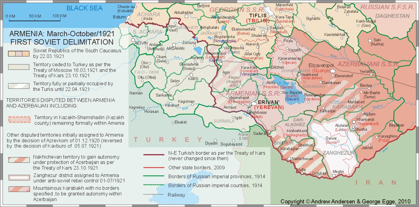
Armenia and the first delimitation of the Soviet South Caucasus, July-October,
1921 In summer and early fall of 1921 the Soviet
Armenia was in effective control of the following territories (See Map 12):
A few comments need to be made regarding
Armenian sovereignty over Zanghezur and Kazakh: (1)
As of today, by “Zanghezur” one usually means modern
province of Syunik in Armenia. However, as of 1917-1921, the county of
Zanghezur embraced much bigger territory including the strategically
important villages of Abdalar (Lachin) and Zabugh. (2)
The Armenian possessions in the county of Kazakh
remained untouched by the territorial adjustments for a short while as a
“cradle of Armenian revolution” where in accordance with the Soviet
ideologized history the communist uprising had been staged in late November,
1920. In fact, even pre-Soviet Armenia never claimed the whole territory of
that county restricting her aspirations to its predominantly
Armenian-populated mountainous part and having little interest to the lower
Kazakh with its Azeri-Tatar majority (excluding a few Tat, Armenian and
German villages). Most of the Soviet
maps depicting Armenia of mid-1921, show her in possession of the county of
Kazakh excluding the strip of land between the rivers Kura and the border of
Georgia just south of Iori river[2].
Some of the maps of that period, however, show Armenian SSR stretching across
Kura and thus embracing the whole county. As of today, it is hard to say
whether this discrepancy was a result of poor quality of early Soviet maps or
the lack of documentation regarding the borders between the new Soviet
republics. We assume that it is quite unlikely that there was any Armenian
administration in 1921 that would claim control of the deserted strip of land
north of Kura and that is reflected in Map 12 where Kura is shown as the
northern border of the Soviet Armenia in Kazakh-Shamshadin. As follows from the above, the Soviet
Armenia did not have any formal control of Karabakh during the period
specified, contrary to the declaration of Azrevkom
of December 1, 1920 in accordance with which Mountainous Karabakh was to
become an integral part of Armenia together with Zanghezur and Nakhichevan.
Map 12. Click on the map for better resolution As was already mentioned, the Treaty of
Kars put Nakhichevan together with some other territories next to it under
the protection of the Soviet Azerbaijan, while the desperate struggle of the
population of Zanghezur prevented secession of this territory from
Armenia. As for the Mountainous
Karabakh, its transfer to the Soviet Armenia was revoked by the decision of Politburo of the Communist Party of
Azerbaijan (the body de-facto running the Azerbaijani Soviet Republic) of
June 27, 1921[3], and
the future of Karabakh was to be decided at the plenary session of the Kavbureau of the Central Committee of
Russian Communist Part (Bolsheviks)[4]
that started on July 4, 1921. After hours of heated debates, the Kavbureau decided to overrun the 1920
declaration of Azrevkom by leaving
Mountainous Karabakh within Azerbaijan and promising it cultural and
territorial autonomy [5].
Sixteen days later, the Central Committee of the Communist party of Armenia
protested the Kavbureau decision
but the protests from Erevan and Armenian-populated parts of Karabakh were ignored by the Kremlin, and even the promised autonomy
was not established in Karabakh until 1923[6].
On July 5, 1921, the Kavbureau also
failed to define the borders of Mountainous Karabakh in general and
the future autonomy in particular leaving it for the future decisions and agreements[7]. The frameworks of this paper do not allow
us to make a detailed analysis of the possible reasons for the Kremlin
support of the territorial ambitions of the Soviet Azerbaijan at the expense
of the Soviet Armenia. We would take the liberty to suggest that oil-rich
Azerbaijan could be more important to the Soviet leadership in Moscow as a
possible spearhead of their expansionist policies in the Middle East and
other Muslim-dominated areas, while the National Uprising in Armenia and
especially in Zanghezur, put Armenian loyalty to the new Soviet system in
question. Until the end of 1921, the Soviet Armenia
also did not include any parts of the county of Borchalo that had been
disputed with Georgia since late 1918. The Kremlinite logic behind keeping
the whole of Borchalo within the Soviet Georgia was the same as behind
keeping the whole of Kazakh within Armenia: the pro-Soviet uprising in
Georgia in February, 1921, started in
a few ethnically Armenian villages of the sector of Lori (Borchalo county)[8],
and ceding that territory to Armenia immediately after the end of
Soviet-Georgian war, could question the legitimacy of the Sovietization of
Georgia[9]. Armenia, Karabakh and the USSR: the Time Bomb Planted To
the Transcaucasian SFSR and the USSR: territorial changes of Nov/1921-
July/1923 In order to soften the loss of formal
independence of the new-conquered Soviet republics of the South Caucasus an
order was given from Moscow to their leaders to form a pseudo-federation of
three units that later were to be incorporated into the Soviet Union - a prototype of the “Global Soviet Republic”
planned by the architects of “the world revolution”[11].
It is important to keep in mind that as soon as the short-lived states of the
South Caucasus were Sovietized, they were run by the local communist parties
that, in fact, were not independent communist parties but constituent parts
of ARCP(B), local branches of “highly-centralized political organization
directed by a small group of men in Moscow”[12]
and bound by strict party discipline. Following the orders from Moscow and Zakkraykom of RCP(B) that replaced the
Kavbureau RCP(B) in February, 1922,
the representatives of the three Soviet republics of the South Caucasus
(Armenia, Azerbaijan and Georgia) signed on March 12, 1922, in Tbilisi the
federal treaty establishing the Transcaucasian
Federal Soviet Socialist Republic (also known as ZSFSR). Less than a year
later, on December 30, 1922, ZSFSR got completely absorbed by the
Bolshevik-recreated empire, through signing the Union Treaty that signaled
the establishment of the USSR formally and formally subordinated the three
Soviet republics (Belarus, Ukraine and the Transcaucasian Federation/ZSFSR)
to the Kremlin. The creation of ZSFSR was preceded by a few
rather major territorial changes that were supposed to put an end to all
possible territorial disputes between the three member-states of the Soviet
federation of the South Caucasus. Most of those changes contributed to the
territorial growth of Soviet Azerbaijan, except the treaty of November 6,
1921, that gave Armenia the sector of Lori of the county of Borchalo that had
been disputed between the two nations since 1918 and finally incorporated
into Georgia during Turkish-Armenian war of 1920 (see above) and southern part of Borchalo sector of the county
bearing the same name (see Map 13). The above adjustment of
Georgian-Armenian border was formally made in accordance with the declared
“ethnical principle” keeping in mind that the above territory had mixed
Armenian, Russian and Greek population with Armenian majority. Other territorial changes that occurred
immediately before and immediately after the creation of ZSFSR were made, as
already mentioned above, in favor of Soviet Azerbaijan. On March 12, 1922,
hours before the establishment of ZSFSR, despite some protests of Georgian
leadership, Azerbaijan was granted the long-disputed poly-ethnic Zakatala
district, and between November, 1921, and July, 1922, Soviet Armenia ceded to
Azerbaijan the following territories (see Map 13):
Map 13. Click on the map for better resolution Mountainous
Karabakh: autonomy created, but what exactly was Mountainous Karabakh? From the point of view of the Tatar
(Azerbaijani) officials both before and after the Sovietization of
Azerbaijan, by Karabakh one should mean the
four sanjaks, or the three counties of the former Russian province of
Elisavetpol, namely: Javanshir, Karyagino (Fizuli), and Zanghezur that
embrace the territory restricted by the rivers of Aras and Kura (in the east
and south), mountain ranges of Mrovdagh (in the north) and Zanghezur (in the southwest). The natural
western border of Karabakh is the line going from the mountain of Klyshdagh
to the mountain of Sarytshly and further to the mountain of Ginaldagh. Since
the 16th century, the described territory was nominally controlled
by the Khanate of Gyanja of the Persian Empire and since the middle of the 18th
century, it was organized into the separate Karabakh Khanate and remained in
that status until incorporation into the Russian Empire in 1823. Accordingly,
the western mountainous part of that territory could be defined as
Mountainous Karabakh. In the early 20-s the mountainous part of the four sanjaks (including the whole
of the Highland county of Zanghezur) was also often called “the Armenian
Karabakh” due to the fact that its inhabited area[13]
was predominantly Armenian-populated although it was also a home of a few Turcic and Kurd-speaking nomadic and
semi-nomadic groups. One should add to the above that even during the era of
the khanates of Gyanja and Karabakh, the mountainous areas of that region
were ruled by local Armenian Meliks
(Princes) thus existing in the form of several semi-independent feudal
mini-states among them Khachen, Jraberd, Varanda, Dizaq and Tsar[14].
From the Armenian perspective,
the above-mentioned territory was not the whole of Mountainous Karabakh
because Armenian political and intellectual elites of the period described,
considered the former Khanate of Gyanja (Gandzak) a part of historical
Kabarakh thus denoting most of Gyanja county of the province of Elisavetpol
between Mrovdagh range and Kura river
as “Northern Karabakh”[15].
Accordingly, the mountainous part of Gyanja county between Shakhdagh range
and the chain of villages including but not limited to Karatschinar, Agjakend
(Shaumianovsk), Borisy, Erketch and Chaykend on both banks of the river of
Geran, was considered a part of Mountainos Karabakh and often referred to as
“North Artsakh”. The described territory was even more homogenously Armenian
than Mountainous Karabakh south of Mrovdagh, local Armenians spoke the same
dialect that was used in the mountainous parts of the three sanjaks, and historically the above area was the core
part of the Armenian melikdom of
Gyulistan[16]. Additionally, another mostly
Armenian-populated part of the county of Elizavetpol (Gyanja/Gandzak)
described above as “the unknown Armenia” was lying to the west of North
Karabakh and included the Armenian villages of Ajikend, Mirzik, Bayan,
Dashkesan, Kushtshi, Zaghlik, Barsum and Tshardakhly. That area is often
referred to as the continuation of Northern Karabakh or as North-Western
Karabakh or Parisos. is also close to Mountainous Karabakh both historically
and linguistically but in contrast to Karabakh Armenians, the Armenians of
Parisos did not attempt to incorporate their lands into the Armenian Republic
and thus that territory was from the very beginning excluded from the
“autonomous Karabakh”[17]. It might be also worth mentioning that the
chain of Armenian towns and villages of Northern Karabakh looks on the map
like a long enclave with a reasonable chunk of Azerbaijani territory between
them and Armenia. That impression could be calibrated though, if one bears in
mind that most of the area south of that chain of Armenian settlements and
almost until the coast of lake Sevan, was practically uninhabited Highland
area that remains sparsely-populated even at present. Following the decision of Kavbureau of July 1921, it was expected
both in Karabakh and in Armenian SSR that the autonomy would be granted to
all Mountainous Karabakh including Armenian-populated areas of Northern
Karabakh. However the reality happened to be quite different from Armenian
aspirations. AONK
and “Red Kurdistan”: 07.07.1923 The history of the autonomous “Kurdistani
County” (also known as “Red Kurdistan”) is short and unclear most of the
documents referring to its existence are either destroyed or “classified”
both in Azerbaijan and Russia. Unclear are also the reasons of its creation.
In any case, the frameworks of this article do not allow us to go into the
details of the history of the “Red Kurdistan’, but it is quite evident that
one of its function was to create a Muslim buffer between autonomous
“Armenian Karabakh” and the rest of Armenia. The county included not only
westernmost parts of the former counties of Javanshir, Shusha and Karyaghino
(now Fizuli) but also most of the lands transferred from Armenian Zanghezur
to Azerbaijan in 1921-22, and the recently Armenian town of Lachin became an
official capital of the Kurdish autonomy although most its governmental
offices were located in Shusha.[21] If one looks at some of the
maps of the South Caucasus published in the USSR between 1923 and 1925, one
may notice that despite the fact that on some of them the town of Lachin
(Abdalar) did not belong either to Armenia, or to AONK, the Karabakh autonomy
was still not an enclave and had connection with Armenian Zanghezur at least
at the village of Zabugh, through which ran a road that connected the two
mountainous regions. If one tries to compare various maps of the area
published during the 20-ies, one gets an impression that the borders of AONK were
regularly redrawn. On the other hand, the jurisdiction of the major towns of
the autonomy and around it remains the same. As of today, it is extremely
hard to say whether this discrepancy is a result of bad cartography, or the
administrative borders were not clearly defined. The problem is aggravated by
the fact that both the military topographic maps of the area published during
the described period, and the documentation related to the re-carving of the
counties and other administrative units is still classified and not
accessible to the researchers. In any case, basing on the maps that still
exist and be found in the libraries as well as on the research made by Robert
Hewsen, Tim Potier and Artur Tsutsiev[22],
AONK had connection with Armenia in Zabugh at least until 1926. Territorial
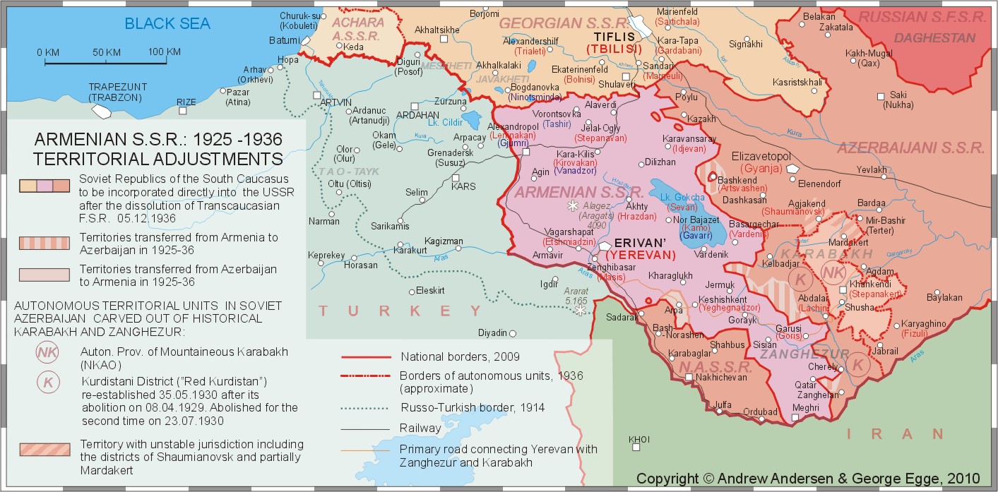
adjustments of 1925-1936 and the dissolution of ZSFSR The years of 1925-36 saw some more changes
on the administrative map of the South Caucasus especially in Mountainous
Karabakh and around it. During eleven-year period that ended up with the
dissolution of ZSFSR on December 5, 1936, the soviet republics of the South
Caucasus went through several re-organizations of their administrative
divisions. In Karabakh that process resulted in the abolition of Kurdish
autonomy on April 98, 1929 and its restoration on May 25, 1930.
Re-establishment of “Red Kurdistan” was accompanied by significant
territorial increase: in the south, the autonomous county gained Zanghelan
area and reached the river of Aras thus gaining direct access to Iran. Near
its capital (Lachin area) the Kurdistani county was supplemented with Zabugh
thus cutting AONK off from Armenia, as well as with the villages of Minkend,
Bozlu and Bayandur apportioned from Armenian Zanghezur and a small area
around lake Alagel. Despite the territorial growth of “Red Kurdistan” it lost
considerable amount of Kurd population through migration, famine, political
repressions and assimilation. The autonomy and especially the town of Lachin
were heavily settled by Azeri Turks (Tatars) who were brought there from
various parts of Azerbaijan. Finally, on August 8, 1930 the Kurdistani autonomy
was abolished for the second time. Now AONK became an isolated enclave
surrounded by Azerbaijani territory. In most of the Northern
Karabakh and North-Western Karabakh/Parisos ethnically Armenian villages and
towns were incorporated into new districts of the Azerbaijani SSR. Those
districts were much smaller than old imperial counties, but they were
organized in such a way that the majority of their population was Turkic with
small and rather marginalized Armenian presence. The only part of Northern Karabakh
that managed to be organized into almost purely Armenian district, was
historical melikate of Gyulistan
now known as Shaumianowsky district (the Soviets renamed the town of Agjakend
to Shaumianovsk) In 1925-36 Armenia was forced to cede other
territories to Azerbaijan including a few villages in Zanghezur (finally
leaving Armenia with only half of the pre-1921 Zanghezur county), and a few
villages in Shamshadin around the town of Artsvashen (Bashkend) turning it
into an Armenian enclave inside Azerbaijan. At the same time, the village of
Arpa, previously given to Nakhichevan ASSR[23]
(see above) was returned to Armenia thus restoring
connection between Erevan and the towns of Zanghezur (See Map 14). One can say that by the end of the 30-ies
the borders between Armenia and Azerbaijan were finally stabilized and
started looking approximately the way they looked prior to the escalation of
the Karabakh conflict in the mid-80ies. The finalized borders, however,
satisfied neither Armenians, nor Azeri Tatars[24].
(at that tine the word “Tatar” or “Azeri Tatar” was replaced with the term
“Azerbaijani” or “Azeri”).
Map 13. Click on the map for better resolution |
|
|


![]()