|
|
|
Armeno-Georgian
War of 1918 and Armeno-Georgian Territorial
Issue in the 20th Century By Andrew Andersen and Georg Egge |
|
|
|
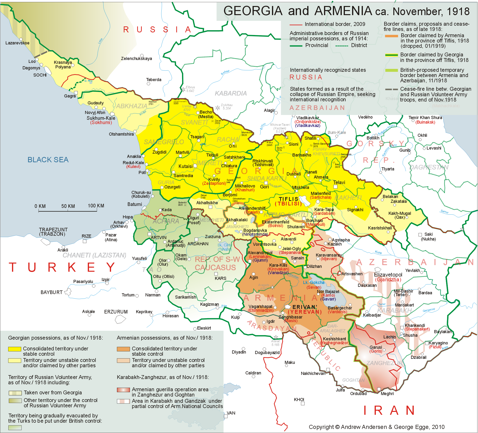
Situation at other Frontiers of Armenia and
Georgia Escalation of the Armenian-Georgian conflict
in the zone of the future border between the two republics took place against
the background of quite complicated situation at other frontiers of both
Armenia and Georgia. Situation
at Western, Southern and Eastern Frontiers of Armenia Upon the surrender of the Ottoman Empire at
the end of October 1918 and the abolition of the boundaries set by the Treaty
of Batum that automatically became null and void,
Armenia found itself in conflict not only with Georgia but also with the
Azerbaijan as well as a number of quasi-state formations, created by the
fleeing Ottoman troops and the local pro-Turkish forces. Armenian plans to take control of the whole
of “Russian Armenia” that would include the entire territory of the Erivan
province, and also the Kars territory - met with resistance on behalf of Kars
Islamic Council (Kars Islam Shurasy), formed on November 5, 1918 in the city of
Kars on the initiative of the commander of the 9th Turkish Army, Gen. Yakub Shevki Pasha and headed
by Fahreddin Bey. With
the armed support of some 30 to 50 000 regular Turkish troops remaining in
the area after the Armistice Mudros, as well
as of at least 8 000 local Muslim
militias armed and trained by the Turks, Kars Islamic Council, declared its
jurisdiction over the entire Kars territory. The Ittihadist-oriented Islamic
Council made it quite clear that Muslims of the former Russian territory of
Kars and other Muslim-inhabited regions of the South-West Caucasus were
prepared to accept either Turkish or Russian sovereignty, while any attempts
of Armenia or Georgia to establish their administration in the above
mentioned area would be met with the mass armed resistance[1]. It should be
clarified here that Kars Islamic Council claimed not only the territory of
Kars but also all the lands of the South Caucasus that had been annexed by
Turkey as per the Treaty of Batum including Nakhichevan and Alexandropol
counties of the province of Erevan, the counties of Akhaltsykh
and Akhalkalaki of the province of Tiflis and the
territory of Batum (See Mар 3)[2].
Кликнуть
мышью на
карту для
лучшего
разрешения In the western part of the province of
Erevan – in the county of Surmalu (near mountain
Ararat) local Kurd tribes launched a guerrilla war against the small Armenian
units that tried to secure Erevan, sovereignty of over that strategically
located strip of land. In the course of Armenian-Muslim entanglement over Surmalu, Japhar Quli Khan of Nakhichevan
proclaimed the so-called “Independent Arasdayan
Republic” with its centre in Igdyr. The new
quasi-state formation claimed not only the county of Surmalu
but also the counties of Sharur-Daralaghez and Nakhichevan, as well as the Muslim-inhabited parts of the
county of Erevan[3]. While waging war
against Armenia, Arasdayan Republic could boast a
few thousand-strong Tatar militia armed and trained
by the Turks and a regular Turkish battalion left in the area contrary to the
provisions of the Armistice of Mudros. During the
first stage of the struggle for the above mentioned disputed parts of the
province of Erevan, the Armenians took over Igdyr
and Daralaghez while the forces of Japhar Quli Khan managed to
keep under stable control only a narrow strip of land narrow strip of land
along the left bank of the Araxes between Nakhichevan
and Ordubad.[4] The armed conflict
dragged on, creating Armenia yet another front in dangerous proximity to her
capital city. If by mid-December, 1918, at least half of the Armenian troops
busy in the war with Georgia could be used against Japhar
Quli Khan, the entire province of Erevan, including
Nakhichevan and Surmalu,
could be placed under stable Armenian control no later than the end of the
year. The eastern frontier of Armenia was also
quite unstable due to the bitter strife with Azerbaijan over parts of Elisavetpol and Erevan provinces. In order to facilitate
the consensus between Baku and Erevan, Major-General
William M. Thomson, the commander of the British expeditionary forces that
started the occupation of the South Caucasus on November 17, 1918,
proposed a temporary boundary between Armenia and Azerbaijan that would run
more or less along the former administrative border between the provinces of
Erevan and Elisavetpol, Only in Ordubad
sector the boundary was to be adjusted in favour of Azerbaijan[5]. Unfortunately, “the Thomson Line” satisfied
neither Armenia, nor Azerbaijan. While the government of Azerbaijan claimed
not only the whole Elisavetpol province but also a
considerable part of the province of Erevan (the three counties that were
also claimed by the above-mentioned “Arasdayan
Republic”, plus one-thier of the county of Novo-Bayazet east of Lake Sevan/Gyokcha), the aspirations of Armenia were aimed at
keeping the whole of Erevan province and annexing the county of Zanghezur and mountainous parts of the counties of Jevanshir, Shusha, Karyaghino, Elisavetpol and
Kazakh in the province of Elisavetpol [6]. By the beginning of the Armeno-Georgian
war, the situation east of “the Thomson Line” was follows:
By the end of the Armeno-Georgian
war (in mid-January 1919) the British command in the Caucasus confirmed its
firm decision to leave Mountainous Karabakh and Zanghezur under the formal jurisdiction of Azerbaijan
until the final decision on the demarcation between the new states in the
region is made at the Paris Peace Conference[11]. Situation
at North-Western, Eastern and Southern Frontiers of Georgia During the same period, Georgia could boast
of relative stability on the northern frontier only, where the Big Caucasian
ridge served as a natural protection against her passive involvement in the
escalating civil war in the Northern Caucasus. The situation in all other
Georgian frontiers was tense and unstable. In the area of Georgian-Azerbaijani
junction a territorial dispute arose immediately after the evacuation of
Turkish forces that, fortunately, did not degrade into armed confrontation.
The government of Azerbaijan laid claims on Zakatala
district as well as on the predominantly Muslim-inhabited parts of the
counties of Signakhi, Tiflis and Borchalo[12]. After the above
claims were strongly rejected by official Tiflis, the government of
Azerbaijan, lacking means to start a war against Georgia, decided to drop
claim to all the disputed territories except Zakatala,
where a semblance of condominium was established[13]. In the southern frontier of Georgia her
troops entered the counties of Akhaltsikhe and Akhalkalaki following the Turkish evacuation and
established full control over them by December 5, 1918[14]. Nevertheless, the
atmosphere in Muslim-inhabited parts of the two counties remained tense[15], while further
Georgian expansion – into the districts of Batum
and Ardahan - was blocked by the British, who
simultaneously began to occupy the district of Batumt,
declaring it a special administrative unit under temporary British
protectorate[16]. The most sensitive area of Georgia before
the beginning of the December war with Armenia, was
the zone of contact between Georgian troops and the armed groups in southern
Russia (both "red" and "white" ones), fighting against
each other and being quite hostile towards any state and quazi-state
formations breakaway from the former Russian Empire. The first Russo-Georgian clashes occurred
as early as in March, 1918, when the units of Bolshevist Red Army invaded
Abkhazia (until then known as the district of Sukhum
of the province of Kutais) and took Sukhum (Sukhumi). In view of the spread of anarchy, the
self-appointed Abkhazian National Council (ANC) appealed to the Georgian government
and later, on July 24, 1918, signed a treaty that confirmed the incorporation
of the district of Sukhum into Georgia providing
that it would enjoy local autonomy[17]. By that time,
regular Georgian troops under the command of General George Mazniev (Mazniashvili) expelled
the reds from the whole district (which was from that time called Abkhazia,
as that was how the region had been called prior to its incorporation into
the Russian Empire in 1864[18]), repelled Turkish
interventionist corps that landed at
the end of June at the mouth of Kodori near Ochamchira[19], and advanced
further to the northwest along the Black Sea coast, taking over the districts
of Sochi and Tuapse at the request of ANC and the
local council of Sochi[20]. One should
mention here that at that moment the government of Georgia was considering to
get some compensation for the territories lost to the Turks as per the Treaty
of Batum by annexing the Black Sea province up to Anapa basing on the fact that the above territory had
been part of historical Abkhazia that, in turn, was part of Georgia for a few
centuries[21]. In September, 1918, the Georgians were
defeated in Tuapse by the Taman Regiment of the Red
Army,[22] which was
retreating from the north under the pressure of the anti-bolshevist White
Army of Generals Alekseev and Denikin that took Tuapse a few days later. By late November, Alekseev- and Denikin's troops completed the defeat of the Red forces
in Kuban and came into contact with the Georgian troops under Mazniashvili in Sochi district. The last delimitation
line established prior to the outbreak of the Armeno-Georgian
war, was the river Loo near the village bearing the
same name[23]. Georgian claims on Abkhazia and the Black Sea province were opposed by the leaders of the Mountain Republic, who wanted to get access to the Black Sea. They were also strongly rejected the command of the Russian anti-Bolshevik Volunteer Army, also known as the Armed Forces of the South Russia (AFSR). The re-deployment of more than half of most of Mazniashvili’s forces from Abkhazia to Borchalo in December, 1918, due to the beginning of the Armeno-Georgian war, facilitated further advance of AFSR in that area. |
|
|
![]()
![]()
![]()