|
|
|
Армяно-Грузинская
война 1918 г. и
Армяно-Грузинский
территориальный
вопрос в ХХ в. Armeno-Georgian War of 1918 and Armeno-Georgian Territorial Issue in the 20th
Century By Andrew Andersen and Georg Egge
|
|
|
|
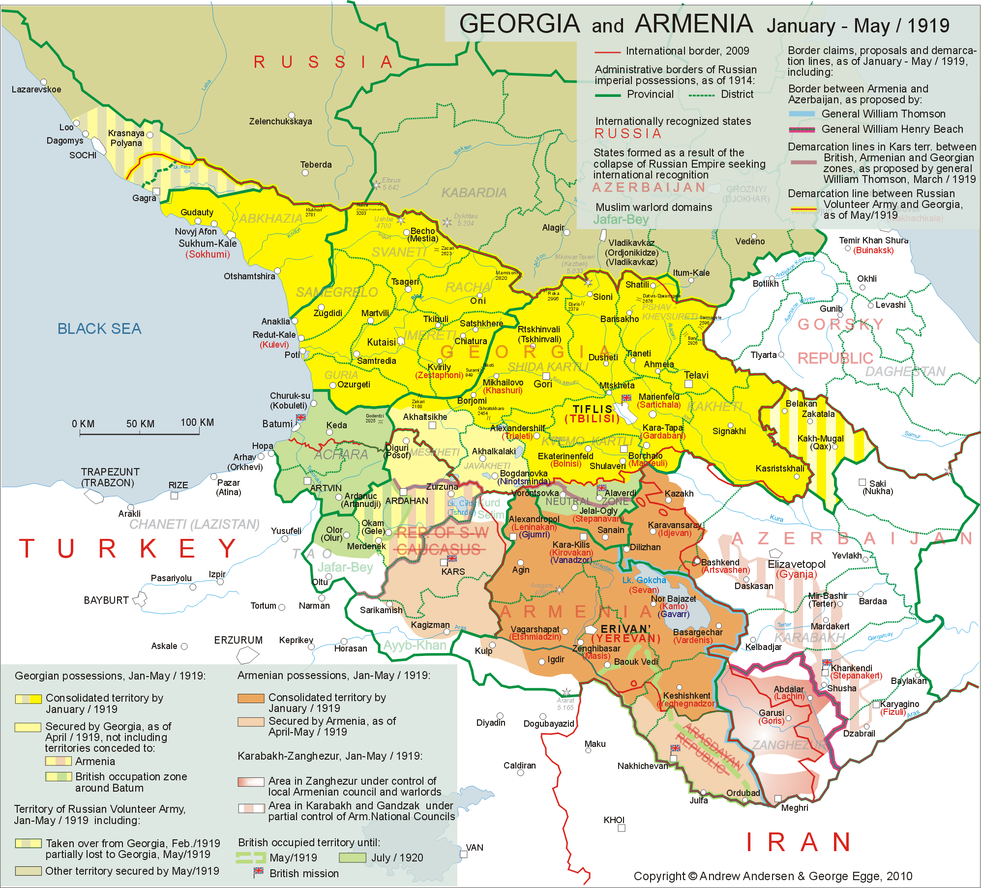
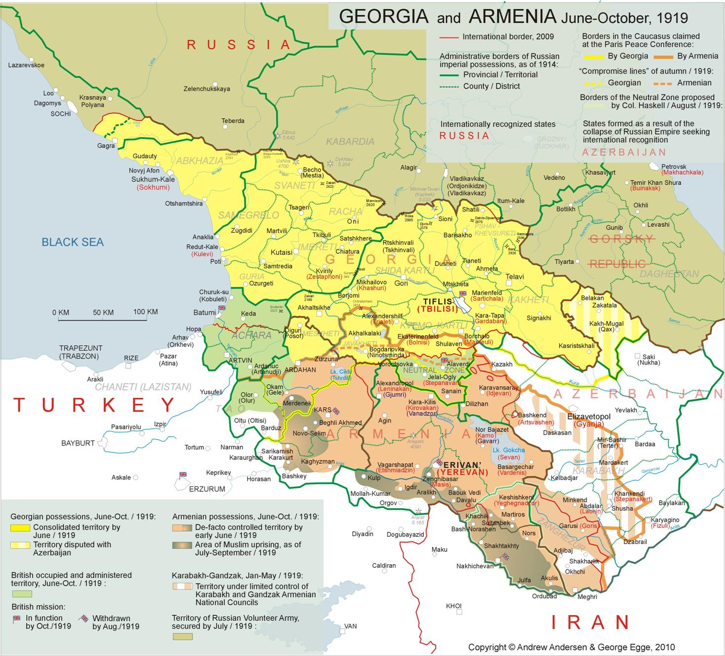
06.1919 - 04.1920: Attempts
of Normalization and Territorial Compromise The December war of 1918 and
provisional Peace agreement of January 1919 did not result in the resolution
of the territorial conflict between Armenia and Georgia. New delimitation
disputes arose in February-July 1919, in the course of the two sister
republics’ expansion the territories of Kars and Batum. Basing on a number of
arguments of ethnic and historical character, a detailed description of which
requires a separate study, Georgia claimed the entire territory of Batum (the
districts of Batum and Artvin), as well as the districts of Ardahan and Oltu
(Olti) of Kars territory, while the Armenian side also claimed the whole of
Olti and most of Ardahan districts considering them part of the former "Russian
Armenia", leaving open the question of the status of Batum. Both Armenian and Georgian
claims for the former Russian territories of Kars and Batum were
unequivocally opposed by the South-West Caucasian Republic (SWCR), a
puppet-state created in Kars on January18, 1919 by the Turkish military
administration that ran the area between April 1918 and December 1918. The
pro-Turkish SWCR government of Fakhreddin (Erdoghan) Pirioglu stationed
in Kars, claimed effective control not
only over the four districts of Kars territory but also over all the former
Russian territories annexed by Turkey as per the Treaty of Batum including
but not limiting to Nakhichevan and Alexandropol counties of the province of
Erevan, the counties of Akhaltsikhe and Akhalkalaki in the province of Tiflis
and Batum territory (former Batum district of the province of Kutais)[1] . The
Kars government rejected both Armenian and Georgian authority and rather
effectively exploited the principle of self-determination declared by the
USA, Britain and France. Indeed at the beginning of its existence, the SWCR
enjoyed some favor on behalf of the British mission in the Caucasus[2] . The British troops even blocked the roads leading to
Kars from the province of Erevan and prevented some 100 000 Armenian refugees
from returning to their homes[3]. At the same time the Azerbaijani government of Khan
Khoisky tried to urge British approval for at least temporary annexation of
the SWCR territory by the Republic of Azerbaijan[4]. The sympathies of allies turned
around in early February of the year 1919 when the paramilitary forces of
SWCR under the command Server Beg started attacking British military and
civil personnel and went so far as to invade Georgian administered counties
of Akhaltsikhe and Akhalkalaki in
order to expand the Kars-controlled area[5]. That
action of the SWCR forced General Thomson to allow Armeno-Georgian takeover
of the troublesome Kars territory during his meeting with Armenian and
Georgian officials on March 14[6].
Following the Georgian counter-offensive of early April 1919, the British
units that had already been stationed in the province of Erevan, entered Kars
on April 6. Four days later, on April 10 1919, the SWCR leaders were arrested
and deported while nine days later, the city of Kars was handed to the
Armenian governor. By April 22, the Georgians completely crushed the
resistance of Server Beg’s paramilitaries in the county of Akhaltsikhe and
the district of Ardahan and put both counties under their control. The
South-West Caucasian Republic was abolished, and the districts of Kars and
Sarykamysh were annexed by the Democratic Republic of Armenia while the
county of Ardahan was taken over by Georgia[7]. The
British command in the Caucasus did not allow either Georgian or Armenian
troops to enter the territory that included the district of Oltu (Olti) which
was claimed by both nations and the sector of Karaqurt claimed by Armenia
leaving it in the hands of local Muslim chieftains until it was once again
taken over by the Turks during the Turkish-Armenian war of late 1920. A few
months later Georgia conceded part of the district of Ardahan (part of Okam
sector and most of Chyldyr sector) to Armenia[8]. As
for the territory of Batum, it found itself under British governorship that
spread over to the parts of the districts of Oltu (part of Olor sector) and
Ardahan (part of Okam sector evacuated by the Georgians)[9]. A
small British garrison was also stationed in the city of Kars (See
Map 5).
Click on the map for better resolution As early as in the middle of March 1919,
when the battles were still being fought to the north of Kars, Major General
William Montgomery Thomson introduced his border proposals to Armenian and
Georgian officials. Aiming at at least temporary (prior to the final decision
of the Paris Peace Conference) resolution of the counter-productive border
dispute between the two sister republics, Thomson proposed that the Armenian
sovereignty over Kars territory would be limited to the districts of Kars and Kaghyzman
only, while Georgia would administer the northern half of the district of
Ardahan. The district of Oltu and the remainder of Ardahan were to be placed
under the British administration together with the whole of Batum territory.
Thomson also recommended the abolition and partition of the Neutral Zone
Lori: the northern part of the zone with the village and copper mines of
Alaverdi was to be returned to Georgia whereas Armenia could administer the
rest of it. Armenia was also expected to acknowledge the Georgian rule over
Akhalkalaki and drop all further claims to that county (See
Map 5)[10]. Being accepted in
Tiflis as a provisional delimitation and with limited enthusiasm the Thomson
plan was protested by Erevan as unfair and illogical. The government of
Armenia was prepared to accept the proposed delimitation in Kars territory
but it categorically opposed the idea of dropping claims for Akhalkalaki and
Lori. This position of Armenia was supported by the head of the US mission in
Tiflis Benjamin B. Moore and British Governor of Batum, Brigadier General
William Cook-Collis[11]. As a result, the
Georgian troops withdrew beyond “the Thomson Line” leaving the considerable
part of the disputed Ardahan district under Armenian and British control.
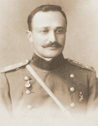
General
Kristaphor Araratian During the second half of 1919
the governments of both Armenia and Georgia started looking for normalisation
of bilateral relations. Exchange of delegations and talks between the two
sister republics that occurred in summer and early fall of 1919, resulted in
a series of agreements signed in such spheres as trade, transit and the
rights of minorities. A few public speeches made by the leaders of both
nations (Ramishvili, Vratzian, Zhordania, et al.) were marked with the spirit
of reconciliation and collaboration[12]. Some
progress was also reached in terms of possible territorial compromise by
attempting to adjust the claims of the two nations in the counties of
Borchalo and Akhalkalaki as well as in Kars territory. That task was far from
being easy as the Armenian borders proposed by «the Delegation of Integral
Armenia” at the Paris Peace Conference were only slightly modified if
compared with Erevan’s territorial aspirations at the beginning of the
Armeno-Georgian War in late 1918, while Georgia still insisted on her rights
to the whole of the former province of Tiflis and the two districts of Kars
territory (Ardahan and Olty)[13].
Nevertheless, the compromise became possible in July 1919, when Armenian
Defence Minister General Kristaphor Araratian submitted a new border proposal
in accordance with which Armenia was to drop claims to almost two-thirds of
Akhalkalaki and the northernmost stripe of the Neutral Zone (to the north of
Alaverdi) and to agree with Georgia’s possession of some 40 per cent of the
district of Ardahan (Kars territory) to the north of Kura. “The Araratian
Line” was to run along the Somkheti Range[14]
to the south of the northern border of the Neutral Zone and
after running a few miles further to the north along the Javakhi Range, it
was to go west along the border of the highland part of the county of
Akhalkalaki embracing the village of Bogdanovka (Ninotsminda), and further on
– to the north of the lakes Khinchalo and Khozapin (Kartsakhi) but to the
south of lake Toporovan until it touched Kura river at the administrative
border between the province of Tiflis and the district of Ardahan. In Ardahan
it was identical with already existing Armeno-Georgian demarcation line up
until the border of British-administered Batum
territory (see
Mар 6)[15].
Click on the map for better resolution Being presented to the Georgian
Delegation in Paris this project was, nevertheless, not accepted as the basis
for the future state border between he two nations. The Georgians failed to
see any major concession in the above proposal largely due to the fact that
most of the disputed territory “granted” to Georgia by Araratian was already
under firm Georgian control. Nevertheless, the official Tiflis came out with
a counter-proposal reflected in a foreign ministry memorandum stating that
Georgia could be satisfied with the northern half of the Neutral Zone (with
Alaverdi copper plants) along “the Thomson Line” (see above) and was prepared
to drop her claims to the district of Olti (Kars territ.), especially keeping
in mind that the above district was de facto
controlled by the Muslim militias of Japhar-Bey[16]. Georgia was,
however, not prepared to cede any part of Akhalkalaki to Armenia and claimed
not just the northern part of Ardahan district but the whole of it[17].
The Georgian compromise proposal was, in turn,
rejected by Armenia. Despite the above disagreement, the leaders of
the two sister republics of the South Caucasus facing numerous internal and
external problems kept looking for some settlement. An Armeno-Georgian
conference that took place in Tiflis in September, 1919, was marked by the
spirit of reconciliation and resulted in signing of a number of new
agreements vital to both countries in November, 1919. However, the two
nations failed to achieve territorial settlement that would be mutually
satisfactory despite the fact that at the very last moment Armenian
delegation agreed to drop all claims to Akhalkalaki in exchange for Alaverdi
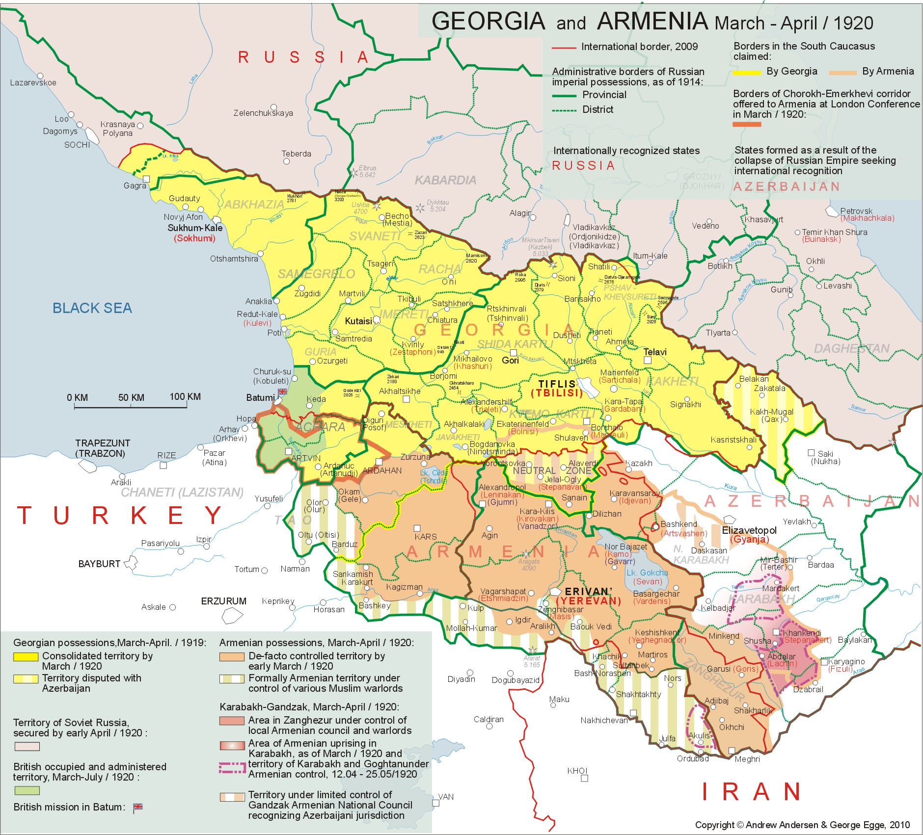
copper mines[18]. Half a year later, an
additional territorial dispute arose between Armenia and Georgia, this time
regarding the future status of the Turkish Lazistan east of Trebizond and
British-administered Batum territory and Armenian claims for a part of the
port of Batum with the left bank of Chorokh River (the so-called
“Chorokh-Imerkhavi Corridor”) and the full exterritorial control over the
Georgian part of the railway branch from Alexandropol to Batum
(see Mар 6a)[19]. The prospective
incorporation of Chorokh-Imerkhevi corridor and Lazistan into Armenia caused
protests on behalf of Georgian delegation and in Georgia proper where the
whole territory of Batum was considered unequivocally Georgian province of
Achara (Ajaria) and Lazistan was referred to as historically Georgian
province of Chaneti. As a result, Georgian troops were sent in late March of
1920 across the administrative border between the district of Ardahan and the
territory of Batum to occupy eastern half of the territory up to Khulo-Ardanuch
line[20].
Meanwhile the Allied Comission dismissed Georgian claims to Lazistan
asserting that despite some Georgian origins of the Laz people they never
express any willingness to be incorporated into Georgian state[21].
Click on the map for better resolution The San-Remo Conference that
held from 19 to 26 of April, 1920 and saw the new territorial strife between
Armenia and Georgia, signalled the divestiture of the Allied leadership away
from most of their obligations in regards with both nations of the South
Caucasus including the refusal to provide and use a military force necessary
to guarantee their safety and integrity. The conflict over the “Chorokh-Imerkhavi
Corridor” and the projected ex-territorial railway in San-Remo, resulted in
another destructive blow to the reputation of both Armenia and Georgia at the
Peace Conference. The disputed area was finally annexed by Georgia in July,
1920, but that conflict significantly undermined the future Western support
of both Armenian and Georgian cases[22],
and the diplomatic representatives of the two nations were asked to refrain
from appealing to the Allied Powers until they resolved all the disputes bilaterally[23]. As of today, it would hardly be
an exaggeration to state that of both the December war of 1918 and the new
territorial disputes between Armenia and Georgia that remained unresolved
until the fall of 1920, not only severely damaged the reputation of the two
South Caucasian republics but also gave the leading Entente Powers grounds to
withdraw their support of the two new democracies and delay even de-facto
recognition of their independence (Armenia, for example, was granted de-facto
recognition only in January 1920, less than a year before her fall, whereas
de-jure recognition of Georgia occurred less than a month before her capital
fell to the Soviets on February 25, 1921).
|
|
|

![]()
![]()
![]()
![]()
![]()